Most people who search for Mt. Talamitam in Nasugbo, Batangas land on articles that are a few years out of date, and several of those skip the mandatory tour guide policy now enforced at the jump-off. That single gap can catch a group off guard on the morning of the hike. This article is from a visit on April 12, 2026, starting from the Sitio Bayabasan jump-off in Barangay Boso-boso, and covers what the trail, the summit, and the full day after the descent actually look like now.
The four of us made this trip on roughly a day's notice. A friend, Sheran Baurile, floated the idea for the weekend, and by the following morning we were on a bus out of Tagaytay. The planning was minimal. The experience was not.
Getting to the Mt. Talamitam Jump-Off in Nasugbu, Batangas
From Olivares in Tagaytay, the ride to the Sitio Bayabasan jump-off takes roughly an hour and a half by bus at 65 pesos per person. Google Maps handles the route without confusion, and on this particular day there were no wrong turns worth noting. The road narrows as you approach the barangay, but the approach reads clearly enough that hesitation is unlikely.
At the jump-off, food vendors and a registration point share the same small area. A tour guide is now required for all hikers, charged at 700 pesos per group regardless of headcount. The guides are stationed there and available without advance booking, so nothing needs to be arranged ahead of time. Once you have paid and completed the ascent, waiting for the guide on the descent is optional. You can let the guide lead you up, then head down on your own or take a different route back if the terrain already feels familiar. That flexibility is real and not always communicated at registration.
The environmental fee is 45 pesos per person on top of the guide cost. Bring exact change if possible.
The Trail Up: Forest, Then Open Sky
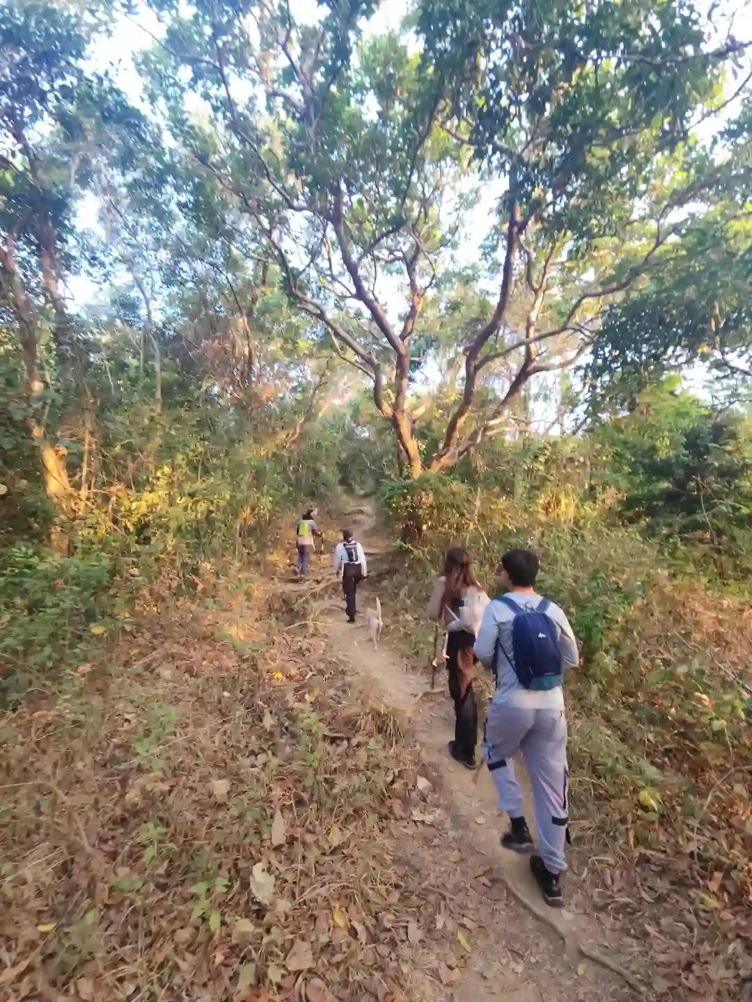
The lower portion of the Mt. Talamitam trail moves through a shaded corridor of trees, the kind that filters light sideways in the early morning and turns the dried leaves underfoot a warm copper color. The path is narrow packed dirt, worn smooth in the middle from years of boots, with roots and small rocks sitting across it at irregular intervals. A dog from the area joined the group uninvited somewhere near the registration point and stayed for most of the climb.
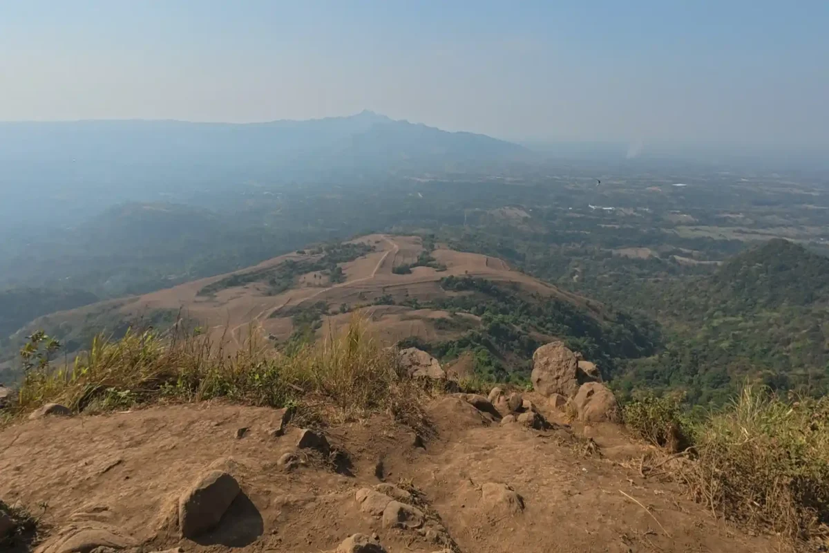
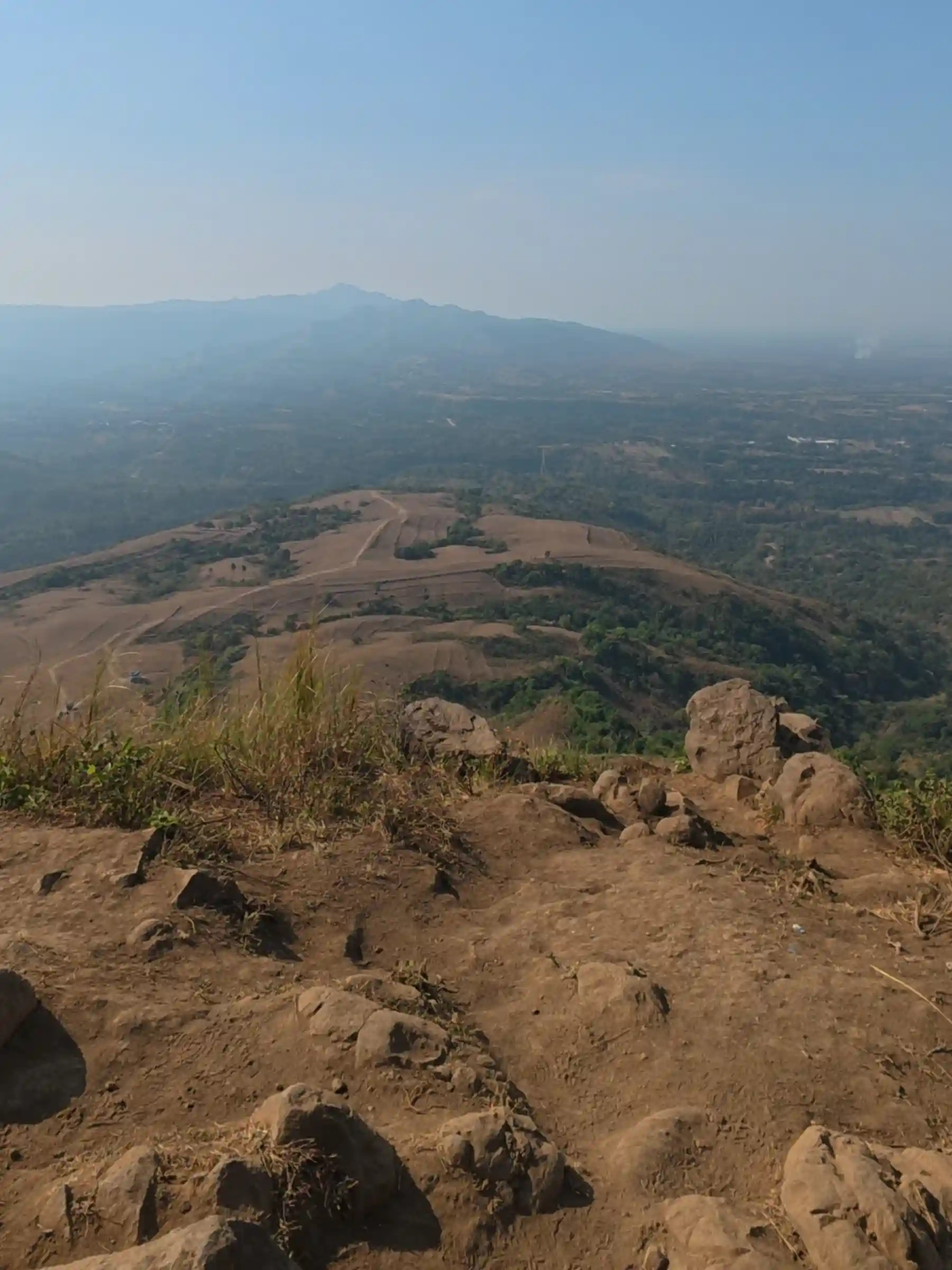
What changes the experience entirely is the moment the trail breaks out of the trees. The transition is abrupt. One step there is canopy overhead, and the next there is nothing but open sky and the smell of dry grass warming in the morning air. The air carries almost no weight up here, noticeably cleaner than anything below the ridge, and the grassland opens wide in both directions with no barrier between the hiker and the horizon.
The grass across most of the slope is a deep, toasted brown, the color of a long dry season, pressed flat in some places and still standing in others. The terrain ahead rolls in long undulating waves, occasionally broken by a low tree or a cluster of scrub, and the valley falls away cleanly behind.
What Mt. Talamitam Looks Like from the Grassland
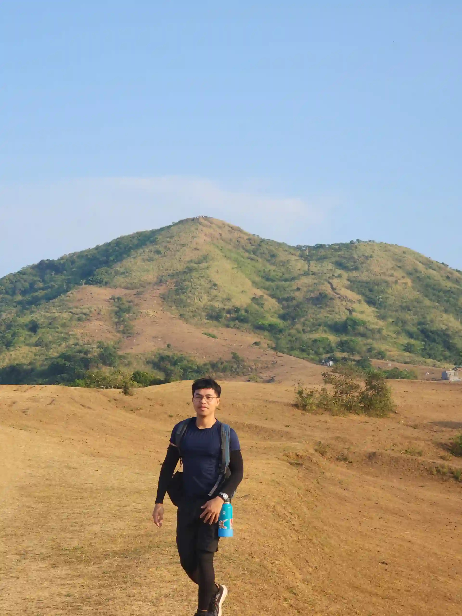
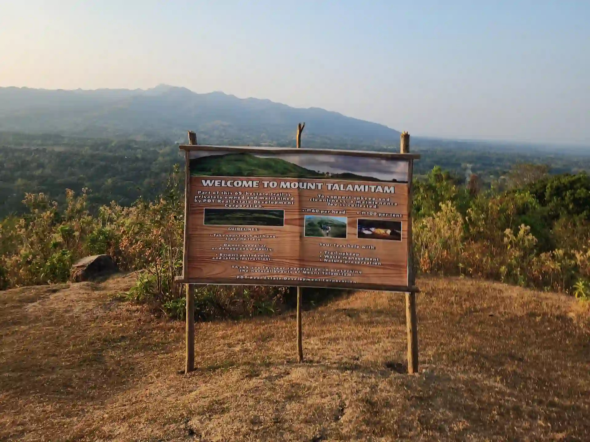
The summit is visible from most of the open section, a clean triangular peak rising against blue sky. A welcome signboard placed mid-trail identifies the area as part of a 65-hectare privately managed property under PDT Real Estate Development Corporation and lists the applicable fees.
The scale of the terrain is what tends to surprise people. Most photographs of Mt. Talamitam frame a small group against the peak, which is accurate but makes the grassland feel more compact than it is. Standing in it, the rolling ground between the treeline and the upper section is wide enough that camping clusters visible in the mid-distance look small against the hillside.

Midway along the open section, a vendor was leading a horse loaded with supplies toward the camping area partway up the slope. It is an easy detail to pass over, but it says something concrete about how the mountain operates on weekends. There is an informal resupply economy moving goods up and down this trail regularly, and the groups staying overnight are not particularly isolated.


The Summit of Mt. Talamitam: Wind, Views, and Halo-Halo
At 630 meters above sea level, the summit is where the cold breeze that accompanied the entire hike concentrates. Steady enough to cut through a light shirt, it turns what would otherwise be a strenuous April morning into something considerably more manageable. The view from the top reaches across a wide, haze-softened valley, with the mountain ranges of Batangas layered in the distance, and the full sweep of the grassland below visible in a single frame.
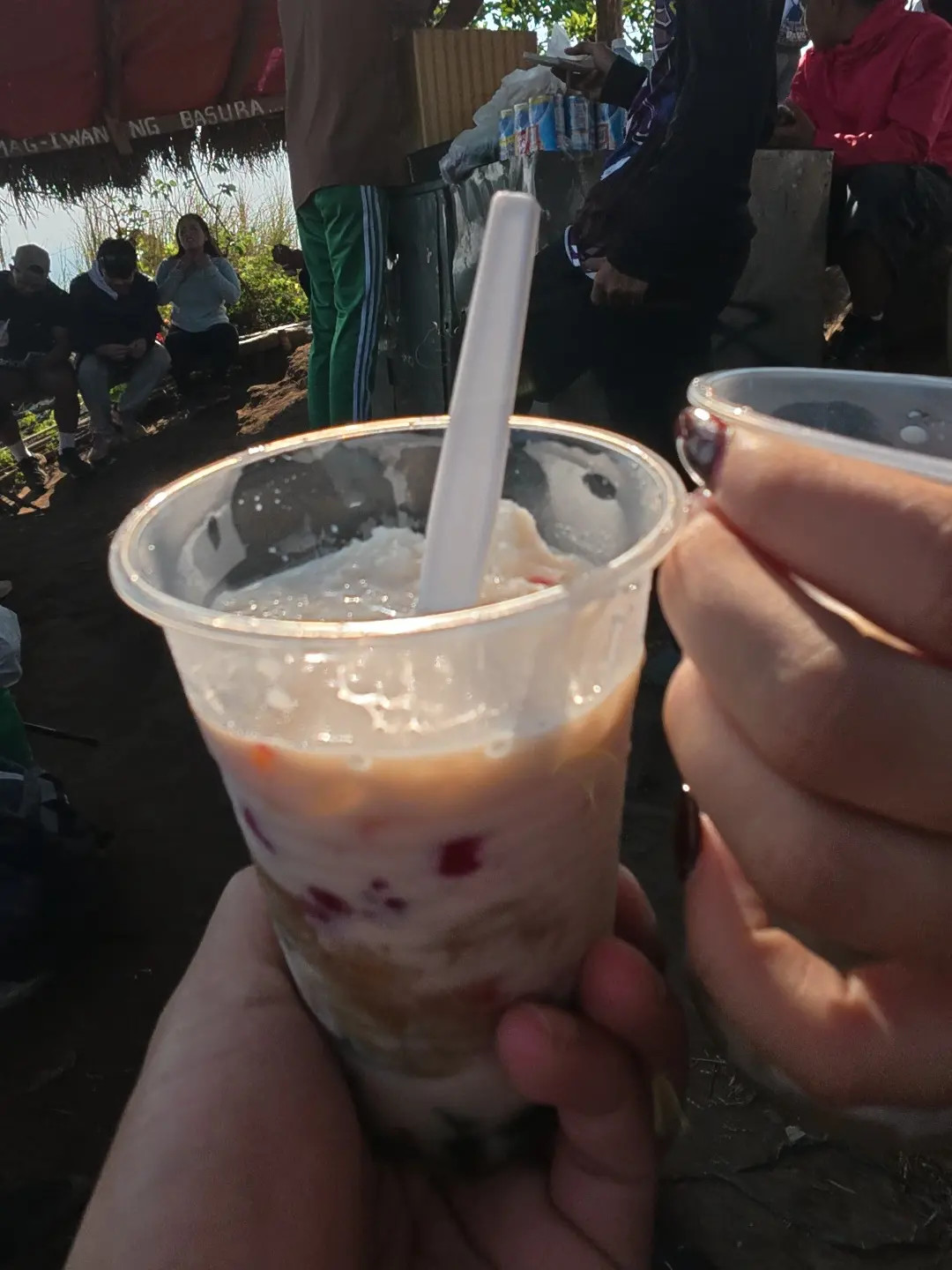
Vendors sell halo-halo at the top for 80 pesos an order. Getting dessert ingredients to 630 meters is a logistical commitment worth acknowledging, and after an open climb under an April sky, the cold dessert does exactly what it is supposed to. The summit area held a steady number of hikers that morning, enough to form a rotation at the marker for photographs, but not so crowded that any single group waited long.
Photographers were few. Most people were there for the hike rather than the frames, which is an observation worth sitting with because the open grassland and clean ridgeline offer compositional room that a forested summit simply cannot provide. The place photographs well across light conditions, and the mid-morning haze over the valley softens the background without flattening the foreground.
After the Summit: River Swimming and the Meal at the Jump-Off
The group descended by a different trail than the one used going up, which is possible once the general layout is familiar and the guide is no longer needed for navigation. Near the jump-off, there is a river where swimming is free. We went in after the descent, and that detail alone shifts the value of a full-day visit considerably. Most articles about Mt. Talamitam leave it out entirely.

Back at the jump-off after the swim, young coconut is the natural first stop. A vendor there opens them to order, and the water is cold enough to register immediately after the heat of the trail.

We followed the coconut with Batangas lomi at one of the food stalls near the registration area, thick noodles in a pork-based broth topped with chicharon, a halved hard-boiled egg, lumpia, and kikiam, with calamansi, raw onion, and a finger chili served alongside. At 85 pesos a bowl the broth is heavier than most lomi versions served closer to Manila, fattier and more direct, and the chicharon holds its crunch long enough to matter. From there the group walked to the highway and caught the bus back to Tagaytay, closing a full day that moved from the morning ride out to an early afternoon return.
What to Bring and What to Expect on Mt. Talamitam
Technical gear is not required, but a few things make the day meaningfully easier. Water matters most because the climb is open and exposed once the trail leaves the forest, and the summit breeze can mask how much ground you are actually sweating through on the way up. Bring more than feels necessary, and keep snacks accessible for the descent. Extra cash matters too, since the halo-halo at the summit and the young coconut and lomi at the bottom are all cash transactions with no alternatives nearby.
The 700-peso guide fee covers the full group rather than being charged per head, which is more reasonable for a party of three or four than it first sounds. The environmental fee of 45 pesos is per person, paid at registration.
A note on the guide policy. Some older articles describe Mt. Talamitam as a self-guided hike. That is no longer the case. Guides are mandatory and stationed at the jump-off, and registration cannot be completed without one. Budget the 700 pesos into the trip before departure.
Sitio Bayabasan in Barangay Boso-boso, Nasugbo, Batangas is accessible by public bus from Tagaytay at 65 pesos per person. Food stalls, a registration booth, and tour guides are all available at the jump-off without advance arrangement.
Whether the Trip Is Worth Making
Mt. Talamitam in Nasugbo, Batangas earns its reputation through the terrain itself rather than through any single dramatic feature. The grassland is genuinely wide, the summit wind is real, and the 630-meter elevation is achievable in a morning without specialized preparation. A free river swim after the descent extends the day into something more complete than a standard out-and-back hike, and a bowl of Batangas lomi at 85 pesos is honest food that arrives at exactly the right moment.
Photography potential here runs higher than the current volume of images online suggests. The open ridgeline gives a shooter room to work that a forested summit cannot match, and the mid-morning haze over the valley is an asset rather than a drawback when the foreground is as strong as the grassland at this elevation. For anyone within bus distance of Nasugbu, Batangas, the total cost of the day sits comfortably within a modest budget, the guide fee is the largest single line item, everything else stays small, and no private vehicle is needed to close the loop back to Tagaytay.
FAQs
Mt. Talamitam is in Sitio Bayabasan, Barangay Boso-boso, Nasugbo, Batangas. It stands at 630 meters above sea level, making it one of the more accessible summit hikes in the province. The mountain is part of a 65-hectare privately managed property under PDT Real Estate Development Corporation. From the summit, the view reaches across a wide haze-softened valley with the Batangas mountain ranges layered in the distance.
From Olivares in Tagaytay, a public bus to the Sitio Bayabasan jump-off takes roughly an hour and a half at 65 pesos per person. Google Maps handles the route without confusion and no wrong turns were reported on the April 2026 visit. From Manila, Tagaytay is the natural staging point. No private vehicle is required since public buses run the route, and the jump-off in Barangay Boso-boso is accessible directly from the highway.
The trail is manageable for hikers with basic fitness but should not be underestimated on a hot day. The lower section moves through a shaded forested corridor, then breaks abruptly onto open grassland for the rest of the ascent to 630 meters. The exposed upper section has no canopy shade and the April sun is direct, though a steady summit breeze makes the climb considerably more comfortable. The round trip can be completed in a morning without specialized preparation or equipment.
The environmental fee is 45 pesos per person, paid at the jump-off registration. A tour guide is mandatory and charged at 700 pesos per group regardless of headcount, which is the largest single cost of the day. Halo-halo is sold at the summit stall for 80 pesos an order, young coconut is available at the jump-off after the descent, and Batangas lomi at the food stalls there runs 85 pesos a bowl. All transactions at the jump-off and summit are cash only.
Yes, as of April 2026 a tour guide is mandatory for all hikers. Guides are stationed at the Sitio Bayabasan jump-off and available without advance booking, so nothing needs to be arranged before arriving. Registration cannot be completed without one. Some older articles describe Mt. Talamitam as a self-guided hike but that is no longer the case. The guide fee of 700 pesos covers the full group, not per head. Once the summit is reached, descending without the guide is possible if the terrain already feels familiar.
Yes. At 630 meters with a trail that transitions from a shaded forested path to open grassland, Talamitam is widely considered one of the most approachable beginner hikes in Batangas. The ascent is achievable in a morning, no technical gear is required, guides are stationed at the jump-off and accompany every group, and the summit has vendors selling food and drinks. The river swim near the jump-off after the descent and the food stalls at the registration area round out a full day that stays within a modest budget. It sits within the same class as Mt. Batulao and is a natural first or second mountain for hikers building toward more challenging Batangas trails.
Water is the most important item since the upper section of the trail is fully exposed with no shade once it leaves the forest. Bring more than feels necessary, especially in summer months. Snacks accessible during the descent help, and extra cash covers the guide fee, environmental fee, halo-halo at the summit, coconut water, and lomi at the bottom. A change of dry clothes is worth packing if you plan to swim in the river after the descent. No special footwear or technical hiking gear is required, though shoes with grip handle the packed dirt trail and rocky sections better than sandals.